
Showing posts with label March's ride. Show all posts
Showing posts with label March's ride. Show all posts
Saturday, 8 March 2014
March ride to Currie, Riccarton and the Gyle
It would have been ideal cycling weather if it hadn't been for the bitter cold 25-mph winds. But that didn't stop around 32 of us gathering at the Meadows for today's run, which was a second attempt to do the ride that we abandoned in January because of ice.
Because of the high turnout, we decided to split into two groups. Alan Orr led the first party, which headed out to Balerno via Morningside, Craiglockhart, Colinton, and Woodhall, before doubling back along the road to Currie and Riccarton. The second group, under the leadership of Jim Cameron, followed the same route to a point just beyond Colinton. But our progress was slow - probably because of the strong headwinds - so we decided to cut a corner. At Woodhall Farm, we dropped down to the more sheltered Water of Leith path, then on to Currie Kirk, Curriehill Station and the Riccarton campus.
The two groups joined up at the Gyle shopping centre, where we had lunch in the spacious food court. This is not exactly gourmet dining, but it did enable everyone to get fed and watered reasonably quickly. There are around a dozen different food outlets there, so everyone managed to find something they liked.
For the afternoon leg, we followed the path to South Gyle Station, then on to Meadow Place Road and Broomhouse Drive, where we picked up the excellent new cycle path that runs alongside the tram line. This took us quickly to Murrayfield, at exactly the time that several thousand rugby fans were arriving for the Scotland vs. France match. But we were soon clear of that, and it was then just a short hop back to the Meadows, where the two groups re-united for coffee in Peter's Yard.
View March 2014 20-Milers in a larger map
Leaders: Alan Orr, Jim Cameron
Report and map: Mike

Sunday, 10 March 2013
An educational in-town ride for March
For this month's ride (9th March), we took an unusual route through the south and east of the city. Ten people turned up, which I thought was pretty good, considering the awful weather (steady rain and a freezing easterly wind).
We headed out through the Grange and were soon climbing the eastern slopes of Blackford Hill. We paused for a few minutes while our leader, Andy Hunter, pointed out an exposed outcrop known as Agassiz Rock. It was here in 1840 that the Swiss geologist, Louis Agassiz, noticed the distinctive grooving in the rock, which he attributed to the action of ancient glaciers - an observation which laid the foundation for modern theories of geology.
Fortified with that knowledge, we continued down Blackford Glen Road, across Gilmerton Road, and into the Inch Park. After crossing Old Dalkeith Road, we climbed a steep path towards the back of Craigmillar Castle. The path was narrow and somewhat muddy, and we ended up pushing our bikes most of the way up.
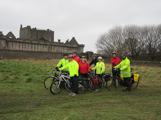 While stopping for a breather near the castle (see photo), Andy told us how Mary Queen of Scots, who lived here at various times in the 1560s, would look out over the fields where we now stood, and where her French entourage was camped. She is said to have referred to the view as "my little France". The name stuck.
A short downhill run now took us to Duddingston Road West, and then to the familiar Innocent Railway path. We left the path at Magdelene Gardens, and headed north by Hope Lane, and so to the Portobello Promenade to look for a lunch stop.
By now, the wind was on the attack with renewed vigour, and the footway was being drenched by spray. With a chill factor well into the minus zone, even the hardened picnickers amongst us decided to forgo the idea of an al fresco lunch. Instead, we opted for the Espy pub, which was warm and welcoming.
As you can imagine, it took a good dose of willpower for us to drag ourselves back to the bikes after lunch. The rain had now stopped, but the wind was still bitterly cold, and we had to dodge the waves as we continued along the prom.
At Seafield, we left the shore, and used the excellent new access point to get to the path by the cemetery. This much-impoved path reaches Leith Links by means of a useful new bridge.
After crossing the links, we headed to the Water of Leith path, which we followed all the way through Warriston, Canonmills, Stockbridge, Dean Village and Roseburn. Most of the group peeled off at various points along this section of the route, so with only three riders remaining, the ride was officially declared finished at Ashley Terrace. At 21 miles, it was another excellent run - and an educational one at that.
View 20milers March-13 in a larger map
Leader: Andy
Photo and map: Andy
Report: Mike
We headed out through the Grange and were soon climbing the eastern slopes of Blackford Hill. We paused for a few minutes while our leader, Andy Hunter, pointed out an exposed outcrop known as Agassiz Rock. It was here in 1840 that the Swiss geologist, Louis Agassiz, noticed the distinctive grooving in the rock, which he attributed to the action of ancient glaciers - an observation which laid the foundation for modern theories of geology.
Fortified with that knowledge, we continued down Blackford Glen Road, across Gilmerton Road, and into the Inch Park. After crossing Old Dalkeith Road, we climbed a steep path towards the back of Craigmillar Castle. The path was narrow and somewhat muddy, and we ended up pushing our bikes most of the way up.
 While stopping for a breather near the castle (see photo), Andy told us how Mary Queen of Scots, who lived here at various times in the 1560s, would look out over the fields where we now stood, and where her French entourage was camped. She is said to have referred to the view as "my little France". The name stuck.
A short downhill run now took us to Duddingston Road West, and then to the familiar Innocent Railway path. We left the path at Magdelene Gardens, and headed north by Hope Lane, and so to the Portobello Promenade to look for a lunch stop.
By now, the wind was on the attack with renewed vigour, and the footway was being drenched by spray. With a chill factor well into the minus zone, even the hardened picnickers amongst us decided to forgo the idea of an al fresco lunch. Instead, we opted for the Espy pub, which was warm and welcoming.
As you can imagine, it took a good dose of willpower for us to drag ourselves back to the bikes after lunch. The rain had now stopped, but the wind was still bitterly cold, and we had to dodge the waves as we continued along the prom.
At Seafield, we left the shore, and used the excellent new access point to get to the path by the cemetery. This much-impoved path reaches Leith Links by means of a useful new bridge.
After crossing the links, we headed to the Water of Leith path, which we followed all the way through Warriston, Canonmills, Stockbridge, Dean Village and Roseburn. Most of the group peeled off at various points along this section of the route, so with only three riders remaining, the ride was officially declared finished at Ashley Terrace. At 21 miles, it was another excellent run - and an educational one at that.
View 20milers March-13 in a larger map
Leader: Andy
Photo and map: Andy
Report: Mike
Subscribe to:
Posts (Atom)
