EDINBURGH 20-MILERS

You are welcome to join our easy-paced bike rides. Click here for all the information you need.

Pages

Tuesday, 25 December 2012

Half-day Christmas ride

Click to view all photos
For the second year running, we had a short ride this year on Christmas morning. Last time, I thought we did well with a turnout of seven. Today, we tripled that number, to 21. And the weather was kind: a completely dry day after nearly a week of dreary rain.

Our route took us down the Mound and along Princes Street, which was delightfully free of traffic. Then came some hard work: an ascent of Calton Hill. We lingered by the City Observatory for ten minutes, taking in the splendid view over the Forth to the Fife Hills. Descending the hill was more difficult than going up, with most of us choosing to push our bikes down the rough, stepped path to Greenside Church rather than trying to pedal down.

From London Road, we headed north through empty streets to St. Marks Park, across the Water of Leith, and on to the Warriston Path. The paths here were busy with dog-walkers and joggers. We paused in Victoria Park for a refreshment break, where we feasted on a cornucopia of home-made mince pies, stollen, shortbread, brownies, and other treats - all unexpectedly and generously provided by members of the group (I can see this becoming an annual tradition).

Our route then took us to Fiveways, Goldenacre, Warriston Gardens, Inverleith Place and Inverleith Park. From Fettes Avenue, we climbed up to Craigleath, where we joined the Roseburn Path. The southern end of this path has now re-opened after a long closure for tram works, so we were able to cut through to Haymarket Yards and out to Haymarket Terrace.

By this time, most of the group had peeled away at various points. The remaining half dozen or so continued past St. Mary's Cathedral to Queensferry Street, where, at 12.30 and after 10 miles, we went our separate ways.

Leader: Mike
Report: Mike
Photos: Livia

Sunday, 9 December 2012

December's ride to Dalkeith Country Park

Dalkeith Country Park is generally closed in the winter, meaning that our rides in the past have been at warmer times of year. This month however the regular ride date (2nd Saturday of the month) co-incided with a Christmas Market being held in the Stables area, so Ken, our leader for the day, took the opportunity for a straightforward (using well known paths) route out with a very similar route back, to get back home before lighting up time (about 3.30pm at this time of year!)

We went out to Musselburgh along the Innocent Railway and then followed Route 1 out to Whitecraig, where we turned right at the roundabout and after a shortish section of road, turned into the Dalkeith Estate - finding that a new gate has been built across the access path. If it had been locked, we would have to had found an alternative route, but luckily a driver was exiting the park at the time we were arriving, and let us through.

The Stables bar kindly opened up their bistro area so that we could all get seated for lunch - mostly hot rolls or soup - I had some mulled wine too which was very warming and welcome. The Christmas market appeared to be a merry-go-round for children, a hook-a-bag stall, "Santa's Grotto" and some stalls in the far corner which I didn't investigate.

We left the estate by a slightly different (and much muddier!) route, coming onto the Old Craighall Road into Musselburgh (where there is a cyclable path on the busy section), and then back pretty much the way we had come, before the last few standing ended up at Peter's Yard for a coffee and cake.

Next ride - Christmas Morning (short route, finished by 1pm)


View 20Milers Dec12 to Dalkeith in a larger map

Monday, 12 November 2012

November ride to Mortonhall (10th November)


For our November ride, Chris Pearson led a group of 20 riders on a fascinating route through the east and south of the city.

In bright sunshine, we left the Meadows via George Square and the Pleasance, then headed through Holyrood Park to Duddingston Village. We then proceeded along Cavalry Park Drive to Duddingston House (built in the 1760s for the Earl of Abercorn, and now housing offices and a conference centre). We continued through the quiet streets of Bingham (passing St Mary Magdalene, which Chris describes as "possibly the ugliest church in Britain"), and then along a short stretch of the Innocent Path.

Just before Asda, we took a new section of path that goes to Fort Kinnaird, and then on to Whitehill Road. We continued through Shawfair, Hilltown, Millerhill Road and Danderhall. At the padlocked gate leading into the Drum Estate, Chris surprised us by apparently using his key to enter the grounds (it was actually a bit of sleight of hand involving what looks like the door to a private house but which actually leads to a public path).

After passing Drum House (a Palladian mansion built by William Adam around 1730), we continued through Gilmerton and along Lasswade Road to the entrance to Burdiehouse Valley Park, and then across Captain's Road and into Gracemount. After crossing Howden Hall Road, we reached Mortonhall.

For lunch, we divided ourselves between the Mortonhall Stable Bar and the café in the nearby garden centre. In the bar, the server asked (politely) for payment in advance, hinting at previous difficulties with cyclists leaving without paying - no further details forthcoming.

After lunch, we took a muddy but picturesque woodland path towards Braid Road, struggling a bit up a section with loose gravel. We crossed Comiston Road into Pentland View, and then on to Braidburn Valley Park.

At this point, the first drops of rain were falling, so we hastily continued on the final section of the route, via Canaan Lane, the Astley Ainslie grounds and Whitehouse Loan, with people peeling off at various points along the way. It was another excellent ride - and, as a bonus, was completely puncture-free.

Leader:
Chris
Photo: Darren

Monday, 5 November 2012

November's ride outline

Route for Saturday 10th November's ride
Chris Pearson will be leading the group on a route that covers quiet roads, little-known paths and seldom-visited villages on the south-eastern edges of the city. There are also two historic houses along the way. Lunch will be at Mortonhall. We'll probably return via the Braidburn Valley path.
 
Chris warns that there may be some short muddy sections. And, he adds, "the steep climbs will be short and the long hills will be gentle".
 
At the lunch stop, you can choose either a snack in the Stable Bar, or the café in the garden centre, which offers a good range of sandwiches, salads, soups, baked potatoes and the like. The courtyard of the Stable Bar is a good choice for those who like to bring their own food.
 
Lights
Although we fully intend to be finished by dusk, there are always the possibility of delays, so we recommend that you bring bike lights on the ride over the wintery months. 

Monday, 15 October 2012

October ride to South Queensferry (13th October)


One of the things we aim to do on our monthly runs is to explore lesser-known cycling routes: to introduce riders to places they might not discover on their own. On that basis, today's run was an undoubted success. Thanks to some careful map-reading and reconnaissance by Ken Roxburgh, we found a delightful place to cycle that was completely new to almost everyone on the ride.

About 20 of us set out from the Meadows, heading up the familiar NCN 1 route to Cramond Brig. There was some light rain at first, but this soon eased off, leaving a slightly damp and overcast day.

After Cramond Brig, we turned west on the minor road past the Craigiehall army base. A couple of miles later, we hauled our bikes up the steep slope to the railway path, which took us quickly into Kirkliston. We then headed north for a short stretch on the shared-use pavement alongside the busy A8000.

So far, so unremarkable. But things started to get interesting when Ken brought us to a halt by a narrow driveway leading into private grounds. A sign by the gate told us that this was one of the entrances to the Dundas Castle estate.

Dundas what? No, I'd never heard of it either. Dundas Castle, it seems, is the family home of Sir Jack Stewart-Clark. The magnficent fortified house, which is also used as a conference and wedding venue, was built in 1818, on the site of an earlier 15th Century castle. It's located in the middle of a 1,500-acre estate, and, despite its size, is completely hidden from the road. The sign by the gate made it clear that this was very much private property.

Fortunately, Ken had contacted the estate office in advance, and had obtained special permission for us to cycle through the grounds. Out of respect for the family's privacy, we had agreed not to go past the house itself, but instead took a delightful back road through a deep, secluded valley. We paused by a charming loch at the base of a craggy cliff, surrounded by mature trees. The only sign of human habitation was a former boat-house, now used as an up-market self-catering venue.

Another couple of miles of pedalling through these peaceful woods took us to the estate's north gate, from where we had a quick downhill run back to civilization, otherwise known as South Queensferry.

After lunch, we took a much better-known route: through the Dalmeny Estate on NCN 76, and so back to Cramond Brig. The last leg was through Barnton and along the Blackhall Path to the Sustrans marker by Craigleath, where we went our separate ways. The total distance to this point was 24 miles.

Thanks to Ken for devising and leading this excellent ride. Thanks also to Jim for back-marking and route-tracing, and, of course, to the staff at Dundas Castle for letting us discover their delightful and secluded corner of the world.

Leader: Ken
Report: Mike

Sunday, 23 September 2012

20-Milers Extra ride to Aberdour (22nd September)

For our last Extra ride of the summer, we were lucky to have some of the best cycling weather of recent weeks: chilly at first but getting gradually warmer, with clear bright skies and virtually no wind. It was an ideal day for our trip into Fife.

Under the capable leadership of Julia Richardson, our 22-strong group headed up the familiar NCN1 route by way of Cramond Brig and Dalmeny. But when we reached the Forth Road Bridge, Julia took us on a less familiar turn-off, through a car park and the edges of a building site, to emerge at the back of the old toll offices. This hidden-from-view spot was where the Queen officially opened the bridge in 1964, and it provides one of the most spectacular views you'll find of both road and rail bridges (usefully, there are also public toilets there).

We lingered at this delightful spot for quarter of an hour, then continued across the bridge at a leisurely pace. It was unusual to cross the Forth on such a clear, wind-free day, and we couldn't resist the temptation to constantly stop, to take photos or to simply gaze across the water.

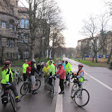
Once clear of the bridge, we got back to the serious cycling. We quickly headed up the main road into Inverkeithing, which was busy with Saturday shoppers and traffic. From the High Street, we took the cut-through by the Mercat Cross into Bank Street, then zoomed down the hill onto the bike path that skirts Inverkeithing Bay (see photo, top).

For the next five miles, we followed the coast, by St. David's Harbour, Downing Point and Donibristle Bay (famous for its radioactive waste), and on past the ruins of the 12th Century St. Bridget's Kirk. For most of this stretch, the route alternates between residential roads with modern housing and pleasant paths close to the water's edge. Navigation can be a little tricky in places, but Julia's local knowledge paid off, and she led us unerringly along the way.

After the kirk, we turned slightly inland, to follow a minor road across fields and a golf course, emerging into the centre of Aberdour. From here, it was only another mile or so to our lunch spot at Silver Sands beach.

According to an information board, this area is officially "Scotland's Riviera". Even on a sunny day like this was, I felt that was a bit of an exaggeration. Still, the beach is surely one of the best in Fife, with fabulous views across the Forth and round the coast (provided you close your eyes to the alumina plant in Burntisland). Most of our group chose to picnic on the beach, while others made for the recently-refurbished café.

For our return trip, we headed back the way we came. The only drawback was that the hill in Inverkeithing that we had earlier zoomed down now had to be climbed up. We didn't linger on the Forth Road Bridge this time, and we were soon heading back along NCN 1 to our starting point on the Roseburn Path. The total distance was 36 miles.

Thanks to Julia for planning and leading an excellent ride, to Alan and Jenny for back-marking, and to the weather gods for giving us the ideal day for it.

Leader: Julia
Report and photo: Mike
More photos from this ride

Tuesday, 18 September 2012

Long September ride

A bit more about this coming Saturday's Extra ride:

At 36 miles, this run will be quite a bit longer than our usual trips. We'll cover the extra distance by starting a little earlier, finishing a little later, and pedalling a little faster - but not so fast as to kill conversation or leave people behind. Our aim is always to have a sociable ride, without undue pressure, and with time to stop occasionally to admire the scenery or take photos.
If you find you can easily manage our normal 20-mile outings and you now want to try something a bit more challenging, I suggest you give this week's ride a try. But if you sometimes struggle to keep up on our normal runs, or you find yourself always at the back, you'll probably prefer to give this one a miss.
The route
Julia Richardson will be our leader this time. She will be conducting us over the Forth Road Bridge, and then eastwards through the intricacies of the Fife coastal path. This is a delightful route, with excellent views for most of the way.
Much of the route will be on well-surfaced paths and roads. But there will be several miles on a somewhat rougher track. This is unlikely to cause any difficulties, and I doubt that we'll have to dismount anywhere. We will, however, encounter several hills. These will be fairly gentle, except for one particularly steep climb on the way back.
Lunch
Our lunch stop will be at the Silver Sands, just beyond Aberdour. This is a beautiful beach with superb views over the Forth. There's a nice cafe there where you can get a sandwich or a bowl of soup. For those of us who prefer to bring our own food, the beach is a good place for a picnic.
If you decide to join the ride but then find it's too much of a struggle, you have the option of taking a train part or all of the way home. There are two trains per hour from Aberdour, but keep in mind that bike space is limited. If more than a couple of people take this option, you might have to wait for a later train.
Time and place
For this ride, we'll forsake our usual meeting point on the Meadows. Instead, we'll gather on the Roseburn Path, by the Sustrans marker at the junction of the Blackhall and Telford paths. If you're not sure where that is, look up South Groathill Avenue on a street map. The access to the bike path is by the toucan crossing near the Sainsbury's petrol station there.
Remember, the ride will start earlier than usual. We'll gather at 09.45, for a 10.00 start. I can't say for sure what time the ride will finish, but we're unlikely to get back to the start point before about 4.30 pm.